

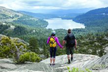
Taking a Lake Tahoe hike is one of the truly special ways to experience all the beauty that the area has to offer. Plus, there are hundreds of networks of different Lake Tahoe hiking trails to play with throughout the basin. From sweat-dripping, big-elevation-gain hikes that lead you deep into the wilderness to road-shot mellow hikes that offer exceptional views but do little as far as elevation increase, there is pretty much a trail for everyone.
Lake Tahoe Hikes in Truckee
The trail system in Truckee offers a different viewpoint of Lake Tahoe hiking. Some of the best trails venture off of Donner Pass and Donner Summit. If you desire to hike far enough, you can eventually hike into Squaw Valley from Donner as well as to a few different huts in the wilderness, Benson Hut and Peter Grubb Hut. Another area that is close to Truckee and is a favored area for hiking is Castle Peak, located just a few miles west off Interstate 80. For a leisurely stroll close to the Truckee River, the Emigrant Trail is recommended. This trail continues nearly 15 miles to Stampede Reservoir, so if you want to take it into an all-day affair, the opportunity is there for you. Another nice easy trail is the Truckee River Legacy Trail that starts from the Truckee Regional Park. Donner Memorial Park also offers gentle hiking. Martis Creek is another exceptional Truckee hike for the entire family, which can be found heading out Highway 267 toward Northstar just after the airport.
Lake Tahoe Hikes in Squaw Valley & Alpine Meadows
Squaw Valley is a main hub for excellent Lake Tahoe hikes in the summer, especially if you enjoy waterfalls. Located at the end of Squaw Valley Road is the Shirley Canyon hike that brings you eventually up to Shirley Lake and then to the High Camp of Squaw Valley (make it a full loop by taking the tram down). This hike is exceptional in the spring and early summer with snow runoff, as there are countless waterfalls as the hike progresses with sitting areas perfect for picnicking. There is another short, flat hike that starts from the Resort at Squaw Creek off of hole #1 of their golf course that connects with the Village at Squaw Valley. This hike is perfect for little ones and those who don't want to gain any elevation. Squaw Valley is also the beginning of the cement bike path that connects with Tahoe City and then splits, traveling a small way down North Shore and a farther distance down West Shore. Located between Squaw Valley and Alpine Meadows and starting off of the bike path is a steep single track that connects with the Tahoe Rim Trail, Three Bridges (also known as Western States). Alpine Meadows has another spectacular hike for the summer, Five Lakes. A steep-in-sections single track that leads to multiple mountain lakes, the swimming they offer is refreshing and exactly the ticket for a hot summer Lake Tahoe day.
Lake Tahoe Hikes in Tahoe City
Tahoe City has one of the best leisurely walks in the Tahoe Basin that meanders along with the Truckee River. Starting from the 64 Acres parking lot, there is a dirt trail that heads north along the left bank of the river. In addition to following the Truckee River, this trail also has a spur trail that leads to Paige Meadows. Tahoe City also has one of the few trailheads for the Tahoe Rim Trail, a Lake Tahoe hike that connects with Brockway Summit and then all the way around the lake in a 165-mile loop (this is also the trail that Three Bridges connects to). Tahoe City also connects with Squaw Valley's cement bike path that continues on, following the shoreline through town and continuing up the West Shore to Homewood.
Lake Tahoe Hikes in West Shore
West Shore offers a multitude of hikes coming from all the various state parks that sprinkle Lake Tahoe's shoreline. West Shore is also the location of various access points to Desolation Wilderness, a spectacular overnight backpacking zone that offers mountain lakes like Lake Aloha, spectacular views and incredible old-growth forests. Another great Lake Tahoe hike for those who are ready to get a sweat on is Rubicon Peak. A steep and demanding hike, the top even offers a little rock scramble for those ready to test their balance. If you enjoy accessing an easier view, Eagle Rock is a quick, simple trail that gives spectacular views of the lake. Access to Paige Meadows is also off of West Shore and gives access to both easy and harder hikes. Another area with worthy hikes that lies on the West Shore a little farther along the journey toward South Lake Tahoe is Emerald Bay. Offering hikes that visit Lake Tahoe attractions, including Vikingsholm, Eagle Falls, Maggie's Peak and Desolation Wilderness, the trail system from Emerald Bay is its own little offering of the full smorgasbord of trail difficulties. One other gradual and basic trail that provides stunning views and easy access to the lake is the Rubicon Trail, which meanders along the water, starting from D.L. Bliss State Park.
Lake Tahoe Hikes in North Shore
Some of the best hiking on the North Shore comes from the Tahoe City Cross Country Center and then leads into a huge network of trails that takes you to Mount Watson or eventually Truckee or Squaw Valley if so desired. You can also access the Tahoe Rim Trail from this juncture, which can take you back to Tahoe City or all the way around the lake. Hiking from Kings Beach is great from various trailheads off Highway 267, offering quick ups that give exceptional views.
The North Tahoe Regional Park located in Tahoe Vista offers family- and dog-friendly Lake Tahoe hiking trails, from nearly flat to challenging terrain, and also a 3/4-mile Sierra native interpretive nature trail.
Lake Tahoe Hikes in Incline Village
Some of the most breathtaking views are offered from the hikes in Incline Village. The reason is that a lot of the water that is closest to this part of the mountainous ridge line is accentuated with hues of turquoise, giving the views a special quality. A few hikes that deserve mentioning include the Flume Trail, which has outstanding views, eventually connecting with Spooner Lake. There's a wonderful short mile hike that is suitable for wheelchairs and strollers off of Mount Rose Highway, Tahoe Meadows. A well-manicured loop, the trail is often framed with blooming wildflowers and lively mountain creeks. There are other harder Lake Tahoe hikes off of Mount Rose, one of the hardest being a full-day excursion to the top of Mount Rose itself.
Lake Tahoe Hikes in East Shore
The East Shore is filled with lovely Lake Tahoe hikes along the lake that link to free public beaches. Park anywhere along Highway 28 and you're bound to stumble upon a single track taking you to a secluded cove or beach. There may be other people there, but the place will still be shrouded in beauty. East Shore is also home to the Flume Trail, one of the best for continually amazing views of the lake. East Shore is also the locale for the multiple Spooner Lake hikes and then Cave Rock's short hike once you connect with Highway 50 off of Highway 28. There are additional access points to the Tahoe Rim Trail on the East Shore as well.
Lake Tahoe Hikes in South Lake Tahoe
You can enjoy a plethora of South Lake Tahoe hiking opportunities. From simple educational trails that wander along the shoreline of Lake Tahoe to major day expeditions like Mount Tallac, South Lake Tahoe is outstanding for offering trails that get you out into the wilderness via foot and single track trail. One area that offers multiple trailheads with varying degrees of difficulties is the zone surrounding Heavenly ski area. Three other areas worth their weight in gold: the Fallen Leaf Lake, Angora Peak and Angora Lakes. Another fabulous outing for the kids is the Taylor Creek Rainbow Stream Profile 1-mile looping trail. The quick walk is flat and paved, making it simple for strollers and for the little ones new to walking.
If you're interested in learning real time information about the trail system, please visit the official Forest Service website for the Tahoe National Forest.